

Expertise


From the early pioneers on the Snowy Mountains Hydroelectric Scheme, to our leaders and innovators of today, our people make us who we are.
Through our network of global specialists and by collaborating with local partners, we connect you with the best teams and capabilities to deliver highly innovative and sustainable solutions.
As an organisation we are continually evaluating ways we can better provide a safe, flexible, inclusive and respectful workplace for our people and clients.
People are at the heart of our organisation, we strive to create a flexible, diverse and inclusive environment that enables our people to thrive to their fullest potential.
Explore career opportunities
The scale of the challenge is significant. According to the United Nations Office for Disaster Risk Reduction (UNDRR) 1, the full economic impact of disasters, including cascading supply chain and ecosystem effects, now exceeds US$2.3 trillion annually, equivalent to around 2% of global GDP. Direct disaster losses have nearly tripled since the 1970s, driven by climate change, growing asset exposure and urbanisation. Importantly, flooding remains one of the most widespread and costly hazards affecting communities and critical infrastructure worldwide. Climate-driven displacement is also accelerating. More than 250 million people have been displaced by climate-related disasters in the past decade, with flooding and extreme storms among the leading contributors. In parallel, global insured losses from floods, storms and wildfires reached approximately US$98 billion in 2025 alone, underscoring the growing financial exposure facing governments, insurers and asset owners.
What is emerging is not a single hazard to design against, but a system of interacting pressures. Inland flooding, storm surge, sea level rise and extreme rainfall increasingly occur in combination, compounding impacts and pushing infrastructure beyond historic design assumptions. In many regions, assets designed using past climate records are now being tested by conditions they were never intended to withstand.
This shift demands a fundamental change in how infrastructure performance under extreme weather is considered. It can no longer sit at the edge of a project as an overlay or compliance exercise. Resilience must shape the earliest decisions about planning, design, funding and delivery, so infrastructure can continue to support communities when conditions become volatile.
Drawing on experience from roads, geotechnical and disaster recovery projects globally, SMEC helps infrastructure owners build more resilient networks, strengthening performance, reducing disruption and supporting faster recovery before, during and after extreme weather events.
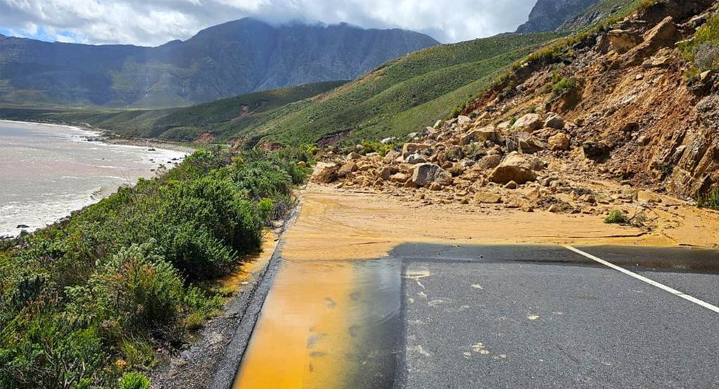
The speed at which a road network returns to service after major rainfall or flooding is a critical measure of resilience. Recovery timeframes directly influence public safety, community access and the scale of social and economic disruption experienced during and after extreme weather.
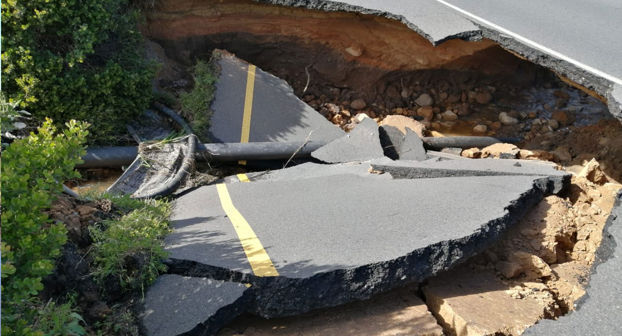
Understanding how roads respond to prolonged and intense rainfall is fundamental to designing more resilient infrastructure in flood-prone areas. Over time, surface cracking can allow water ingress into pavement layers and subgrade materials. As those underlying layers become saturated, structural capacity reduces, increasing the likelihood of deformation, accelerated deterioration and, in severe cases, full structural failure.
When these failures occur, transport agencies may need to implement speed restrictions, lane closures or full network shutdowns to protect residents and commuters. These measures are essential, but they can also isolate communities, delay emergency response and restrict access to essential goods and services. Infrastructure reliability therefore depends on more than withstanding repeated rainfall. It also depends on enabling faster recovery and restoration of service once disaster conditions subside.
This dual focus on resilience and recovery has driven increased adoption of moisture-resistant construction materials in flood and rainfall-prone environments. One notable material option is foamed bitumen. Introduced in Australia in the 1990s as a cost-efficient and sustainable alternative to traditional cement binder in pavement rehabilitation, foamed bitumen has consistently demonstrated strong performance under repeated floods and cyclone conditions. The technique recycles in-situ materials and creates a bound layer that reduces water ingress, helping to preserve structural integrity and load-carrying capacity during and after heavy rainfall. The resulting pavement is more flexible and moisture resistant, with improved resistance to rutting, early cracking, fatigue and failure.
These characteristics deliver value across the life of the asset, reducing maintenance demand and improving post-event recovery. Increasingly applied in both rehabilitation and new construction, foamed bitumen stabilisation helps road networks remain operational for longer during extreme weather, reduces restoration needs after floods and enables quicker reopening to support ongoing community access.
Foamed bitumen rehabilitation is more than a flood adaptation measure, it’s a cost‑effective and sustainable way to extend the life of existing road assets. By reusing existing pavement materials, this approach reduces demand for imported aggregates, lowers haulage requirements and minimises construction waste. The result is lower construction cost, reduced carbon emissions and faster delivery compared with full pavement replacement. Unlike traditional cement-stabilised pavements, foamed bitumen-treated pavements can also be rehabilitated and recycled multiple times throughout their service life, supporting circular economy principles while maintaining pavement performance and reliability. This ability to renew existing assets reduces whole-of-life costs and improves the long-term sustainability of transport networks.
It is to be noted that successful application of foamed bitumen rehabilitation depends on a detailed understanding of existing pavement conditions. Thorough investigations are needed to assess the condition and behaviour of underlying pavement layers and subgrade materials, and to confirm whether rehabilitation is the right intervention. In some cases, additional ground improvement or full reconstruction may be required to achieve the desired level of performance and serviceability.
By investing in early technical assessment and selecting the right intervention, infrastructure owners can move beyond short‑term repairs and deliver road networks that are more reliable, adaptable and sustainable.
Material selection is only one part of the resilience equation. When extreme weather damages critical transport corridors, infrastructure owners must also be able to restore access quickly, understand the causes of failure and deliver solutions that strengthen long-term performance. The reconstruction of Clarence Drive in South Africa demonstrates how these principles can be applied in practice under complex post-disaster conditions.
South Africa’s Western Cape is increasingly exposed to severe rainfall, coastal storms and cut-off low weather systems that place critical transport infrastructure under significant pressure. During the September 2023 Heritage Day long weekend, widespread flooding, and storm resulted in road closures across the province, with the event subsequently declared as a national disaster.
One of the hardest-hit corridors was the R44 Clarence Drive. This route links Gordon’s Bay with Rooi Els, Betty’s Bay and Pringle Bay along a narrow alignment between the Hottentots Holland Mountains and False Bay. The Overberg district contributes more than ZAR20 billion a year to the Western Cape economy, exports more than ZAR4 billion in goods and relies heavily on leisure travel, with more than 70% of surveyed visitors travelling to the region for holidays. Within that system, Clarence Drive supports coastal communities, tourism, agricultural supply chains, emergency access and local businesses, with limited alternative routes when the corridor is closed.
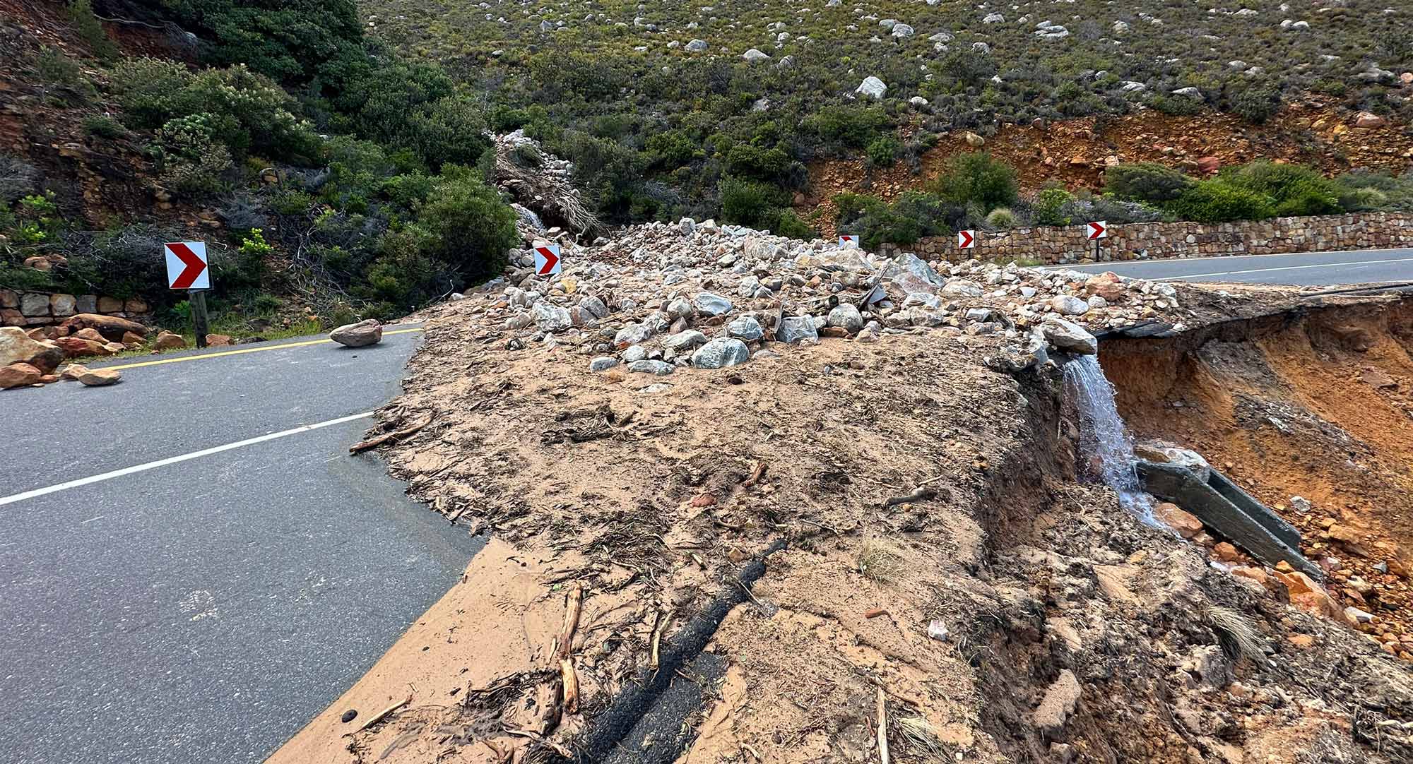
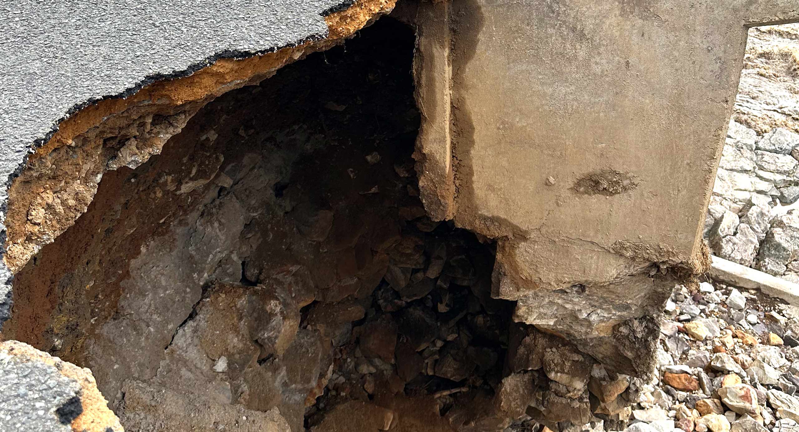
The September 2023 storm caused widespread landslides, rockfalls, embankment scour, drainage failures and bridge damage along the corridor. The most severe failures occurred at the 51.2 km point along Clarence Drive (Km51.2), where scour affected approximately 60 m of the sea-side embankment and roadway, and at Km49.6, where approximately 50 m of downstream embankment was damaged alongside a major rock and mudslide and collapsed stone-pitched safety and gabion walls.
SMEC South Africa supported the Western Cape Government Department of Infrastructure through its emergency response framework, working with Civils 2000 as the main contractor. The immediate priority was to restore controlled access before the December peak tourism period. The longer-term task was to develop permanent repairs suited to a corridor shaped by steep slopes, fractured Table Mountain Group sandstones, intense mountain runoff, live traffic, limited working space and ongoing geotechnical risk.
The engineering response began by diagnosing the failure mechanisms, rather than treating the damage as isolated surface defects. Slope stability, stormwater behaviour and constructability were closely linked. Saturated slopes and concentrated runoff had eroded embankments from beneath the road, while the damaged corridor limited access for investigation and construction. In several locations, debris first had to be cleared, and safe access created before ground conditions could be confirmed.
Initial designs were developed using site observations and available information, then validated and refined as debris was removed, excavations exposed rock levels, groundwater seepage became visible and material behaviour could be tested. This adaptive approach enabled construction to commence quickly while ensuring permanent works remained responsive to actual site conditions, reducing uncertainty without compromising long-term performance.
At the major embankment failures, the repair strategy combined reinforced-earth embankments, geogrid reinforcement, gabion box facings and rockfill toes. The geogrids strengthened the reconstructed embankments, the gabion facings protected the road edge from future erosion, and the rockfill toes provided robust support at the base of the repaired fills.
Temporary lateral support, including self-drilling anchors, drains and shotcrete, stabilised excavations while controlled one-way access was maintained. Limit equilibrium and finite element analysis were used to test stability assumptions and confirm that the reinforced embankment and temporary support solutions were suitable before construction proceeded.
Constructability shaped the repair sequence. At the major embankment failures, the contractor could not rely on conventional lower-level access or large work platforms. Top-down excavation, progressive stabilisation and bottom-up reconstruction allowed the team to create a safe working space while rebuilding the ground needed to complete the works.
Drainage was treated as a primary risk measure, not an ancillary repair. At Km49.6 and Km51.2, upgraded culvert arrangements, gabion step-down structures and 800 mm HDPE discharge pipes were introduced to convey stormwater lower down the steep embankment and reduce the risk of concentrated scour beneath the reconstructed road. Locally sourced rounded sandstone in the gabion facings helped the repaired embankments sit naturally within the mountain and coastal landscape.
The Clarence Drive recovery demonstrates that successful disaster recovery extends beyond restoring access. Lasting network reliability depends on understanding why infrastructure failed, recognising the interaction between water, ground conditions and construction constraints, and delivering solutions that reduce the likelihood of repeat failure.
As extreme weather events become more frequent, adaptive engineering approaches that combine rapid response with long-term resilience will become increasingly important. The project illustrates how post-disaster reconstruction can strengthen infrastructure performance, improve long-term infrastructure performance and restore confidence in critical transport corridors that support communities, economies and regional connectivity. The approach was recognised with a CESA Aon Engineering Excellence Award in the R50 million to R250 million project category, highlighting the value of adaptive engineering in delivering resilient infrastructure under challenging conditions.
Australia’s northern coastline is highly exposed to tropical cyclones with the Bureau of Meteorology recording an average of 9–11 tropical cyclones per season. Associated flooding events also regularly cause multi-billion-dollar damage across Queensland’s transport, water and community infrastructure networks. The Queensland Government’s disaster resilience and recovery frameworks recognise these events as a growing risk to critical infrastructure systems, with multi-billion-dollar recovery programs increasingly required to restore essential transport, water and community networks after major disasters.
In Far North Queensland alone, major events such as Cyclone Debbie (2017), which caused an estimated AU$2 billion in insurance losses across Queensland, and Ex-Tropical Cyclone Jasper (2023), which delivered record rainfall and widespread flooding across the region, have highlighted the vulnerability of coastal transport corridors to cascading failures. These events frequently isolate communities, disrupt freight and tourism supply chains, and place significant pressure on recovery systems, reinforcing the need for resilient, adaptable infrastructure design aligned with Queensland’s broader disaster management and climate adaptation strategies.
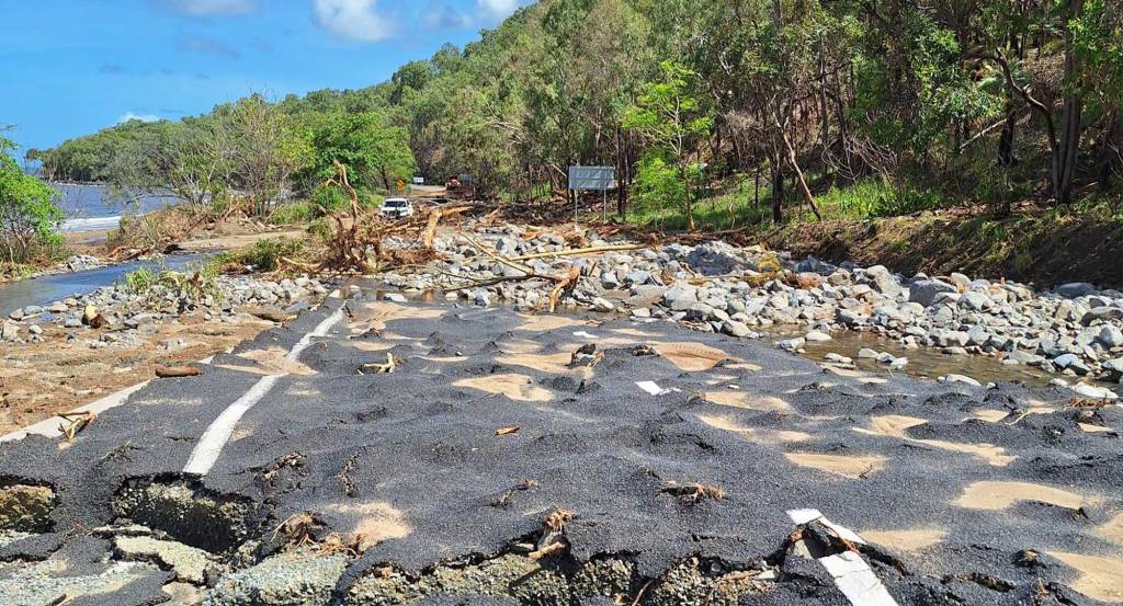
When Ex-Tropical Cyclone Jasper hit Far North Queensland in Australia on 13 December 2023, the Captain Cook Highway suffered extensive damage, disrupting communities and regional economies between Cairns, Port Douglas and Mossman.
The Captain Cook Highway is a critical coastal transport corridor in Far North Queensland, linking Cairns, Port Douglas and Mossman and supporting regional tourism, freight, emergency access and daily commuting. It forms the primary north–south coastal connection and the only sealed road access for several communities along this stretch, serving a region that attracts more than 2 million visitors annually and contributes around AU$3–4 billion to the local tourism economy.
The corridor carries 10,000–15,000 vehicles per day during peak tourism periods, with demand driven by seasonal visitation and cruise arrivals into Cairns. It is also a vital freight and logistics route for agriculture, marine industries and construction, with limited alternative routes meaning any disruption has immediate and significant impacts on regional connectivity, economic activity and supply chain resilience.
SMEC worked with the Queensland Department of Transport and Main Roads (TMR) and the construction contractor to provide design development, design review and geotechnical expertise that supported rapid recovery decision-making. With recovery works jointly funded by the Australian and Queensland governments through the Disaster Recovery Funding Arrangements2 (DRFA), the immediate priority was to restore road access quickly while recognising the scale and complexity of the repairs required. SMEC’s team addressed constructability and foundation risks early and supported rapid design decisions in a post-disaster environment where safety, timing and funding constraints were critical.
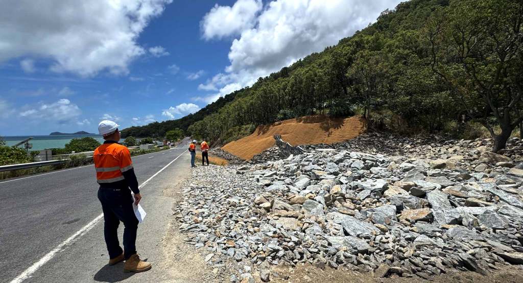
The project team addressed over 80 geotechnical failures and widespread pavement damage across steep, landslip-prone terrain following extreme rainfall impacts. Debris flow mitigation systems were designed across seven high-risk sites, including barriers capable of withstanding vertical debris loads of up to 2,500 kilonewtons, significantly reducing the risk of repeat slope failures and corridor closures.
Comprehensive geotechnical investigations, including seismic refraction surveys, informed barrier placement and design optimisation to balance performance, constructability and safety in complex terrain. The program also incorporated hydraulic analysis at critical locations such as the Mowbray River Bridge, alongside targeted pavement rehabilitation guided by detailed pre- and post-event condition assessments.
Environmental and cultural considerations were embedded throughout the remediation approach. Barrier and erosion control designs were refined to protect aquatic habitats, maintain fish passage and support revegetation, while stabilisation measures such as coir matting and bonded fibre seeding reduced sediment movement and improved slope recovery. Remediation footprints were carefully adjusted to avoid impacts on protected ecological and cultural heritage areas, demonstrating that durable infrastructure can be delivered in alignment with environmental stewardship in sensitive regions.
The Captain Cook Highway Disaster Recovery project highlights the shift from reactive disaster recovery to long-term reconstruction. Through forensic failure analysis, adaptive engineering solutions and collaborative delivery models, critical transport links can be efficiently reinstated to their original condition, rather than quickly repairing surface damage.
This approach ensures continued strength, connectivity, safety and economic stability across vulnerable transport corridors, and re-embeds long-term performance and reliability into assets exposed to increasingly frequent and severe climate-driven events.
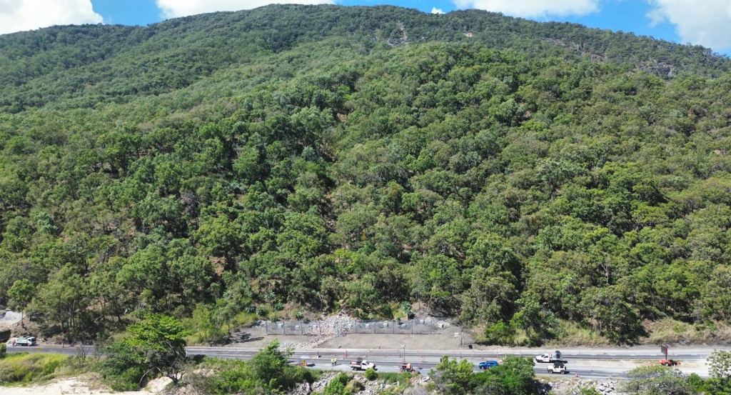
As rainfall events become more intense, frequent and unpredictable, the benchmark for resilient road infrastructure is evolving. Success is no longer measured solely by whether a road withstands an extreme event, but by how effectively it maintains connectivity, supports communities and enables recovery when disruption occurs.
This shift requires a more integrated approach to infrastructure delivery; one that considers resilience, sustainability and whole-of-life performance together. Material selection, pavement design and rehabilitation strategies must not only perform under increasingly challenging conditions, but also minimise resource consumption, reduce lifecycle impacts and support the long-term adaptability of transport networks.
By embedding resilience into every stage of the asset lifecycle, infrastructure owners can strengthen network reliability, maintain critical freight and community connections, and reduce the economic and environmental costs associated with repeated repairs and reconstruction. Combined with circular economy approaches such as pavement recycling, resource-efficient design and cost-effective maintenance schedules, these interventions help create infrastructure that delivers enduring value beyond the asset itself.
Ultimately, resilient infrastructure is about more than recovering from extreme weather. It is about creating sustainable, connected and adaptable communities that can thrive, even in the most challenging climates. Through thoughtful engineering, collaborative delivery and a commitment to long-term performance, transport infrastructure can do more than withstand extreme weather. It can help communities stay connected, support recovery when disruption occurs and create lasting value for future generations.