


Marine Survey

From the early pioneers on the Snowy Mountains Hydroelectric Scheme, to our leaders and innovators of today, our people make us who we are.
Through our network of global specialists and by collaborating with local partners, we connect you with the best teams and capabilities to deliver highly innovative and sustainable solutions.
As an organisation we are continually evaluating ways we can better provide a safe, flexible, inclusive and respectful workplace for our people and clients.
People are at the heart of our organisation, we strive to create a flexible, diverse and inclusive environment that enables our people to thrive to their fullest potential.
Explore career opportunities
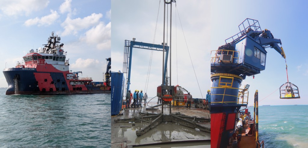
As Singapore accelerates its transition towards a greener energy mix, the need for large-scale renewable energy imports has never been greater. Developers are actively pursuing subsea transmission projects to connect clean energy sources from the region directly to Singapore. Surbana Jurong (SJ) was engaged to provide critical technical support — from project management and stakeholder coordination to technical design and marine survey execution — for one of the country’s first subsea renewable energy transmission projects.

Over the past weeks, our team ventured into Singapore’s waters to undertake a detailed marine survey to map potential submarine cable routes. Our scope included two major technical workstreams:
Using multibeam echo sounders and advanced hydrographic equipment, we created high-resolution 3D models of the seabed as identifying seabed depth variations, contours, and slopes is critical to cable route planning.
Bathymetry helps avoid underwater hazards like shipwrecks, pipelines, rock outcrops, and steep seabed gradients, ensuring safe and efficient cable installation. It also enables us to model hydrodynamic forces (currents, tides) that could impact cable stability over the long term. This step lays the foundational layer for technical design, environmental impact assessment, and construction planning.
We conducted seabed sampling (via core sampling, grab samples) and in-situ tests (such as cone penetration tests, or CPTs) along the proposed cable corridor. Determining the soil composition (e.g., clay, sand, silt, rock) helps assess the seabed’s suitability for cable burial.
We evaluate key parameters like shear strength, density, and sediment layering — all of which influence how easily cables can be buried, protected, and maintained. Understanding geotechnical conditions allows for tailored burial depth design, choice of protection methods (e.g., trenching, rock dumping), and minimisation of installation risks and without this investigation, cables could be improperly buried, exposed to environmental risks, or damaged during operation.
Given the novelty of such projects in Singapore, securing marine survey approvals required proactive collaboration with multiple government agencies. We worked closely with regulators to align on technical standards, environmental protection measures, and maritime safety requirements, setting important precedents for future projects.
With the successful completion of the marine survey, SJ demonstrated our capability to lead and support pioneering renewable energy infrastructure in complex marine environments. This milestone not only advances Singapore’s cross-border energy goals but also showcases SJ’s strengths in delivering technical excellence, regulatory navigation, and project execution for first-of-their-kind projects.
To find out more about the process of planning subsea cable routes, using the Tanjung Pinggir (Batam) to Jurong Island (Singapore) project as a case study to highlight the key steps, download our thought leadership paper below. The paper covers the role of initial desktop studies guided by ICPC recommendations, comprehensive marine surveys (geophysical and geotechnical), stakeholder engagement, and regulatory compliance, whilst emphasising the importance of identifying hazards, mitigating risks, and ensuring environmental protection throughout the planning stages to enable efficient and sustainable cross-border energy solutions.