


Expertise

From the early pioneers on the Snowy Mountains Hydroelectric Scheme, to our leaders and innovators of today, our people make us who we are.
Through our network of global specialists and by collaborating with local partners, we connect you with the best teams and capabilities to deliver highly innovative and sustainable solutions.
As an organisation we are continually evaluating ways we can better provide a safe, flexible, inclusive and respectful workplace for our people and clients.
People are at the heart of our organisation, we strive to create a flexible, diverse and inclusive environment that enables our people to thrive to their fullest potential.
Explore career opportunities
The RPL is a comprehensive planning document that defines the submarine cable route. It consolidates data on segment lengths, seabed types, water depths, burial depths, and protection requirements. The RPL serves as a blueprint for selecting methodologies, tools, and vessels.
The foundation of an accurate and effective Route Position List (RPL) begins with comprehensive survey planning and data collection. Geophysical surveys play a vital role in mapping the seabed topography, employing advanced techniques such as bathymetric mapping and side-scan sonar to create detailed representations of the seabed. These methods help identify obstacles, hazards, and other critical features along the cable route.
Simultaneously, geotechnical surveys are conducted to analyse the seabed’s composition. Tools like cone penetration tests (CPT) measure soil strength and resistance, while core samples provide further insight into sediment characteristics such as sand, silt, clay, or rock. This information is crucial for determining appropriate burial depths and methods.
In addition, environmental surveys are undertaken to identify sensitive habitats, marine reserves, and restricted areas that may require special considerations or avoidance. These surveys ensure that the installation process complies with environmental regulations and minimises ecological impact. Together, these surveys provide the essential data required to develop an accurate RPL that guides successful cable installation projects.
Route optimisation is a critical step in developing a reliable and efficient Route Position List (RPL). This process involves carefully adjusting the cable path to avoid potential hazards, such as shipwrecks, pipelines, and steep seabed slopes, which could pose risks during installation or operation. Additionally, route alignment must comply with environmental regulations to protect sensitive marine habitats and minimise ecological impacts. Where necessary, advanced techniques like horizontal directional drilling (HDD) are used to align the route with challenging landing points, such as rocky shores or environmentally protected areas. By addressing these factors, route optimisation ensures that the submarine cable is installed safely, efficiently, and in compliance with all regulatory requirements.
The RPL organises critical details for each segment of the route, guiding installation methodologies and highlighting site-specific challenges. The table below is a hypothetical example designed to illustrate a typical submarine cable route. To maintain generality and avoid referencing specific geological locations, latitude and longitude coordinates—an essential component of a complete RPL document—are not included in this example. Instead, this simplified RPL focuses on providing a summary of segment distances, water depths, seabed types, burial depths, protection measures, and methodologies.
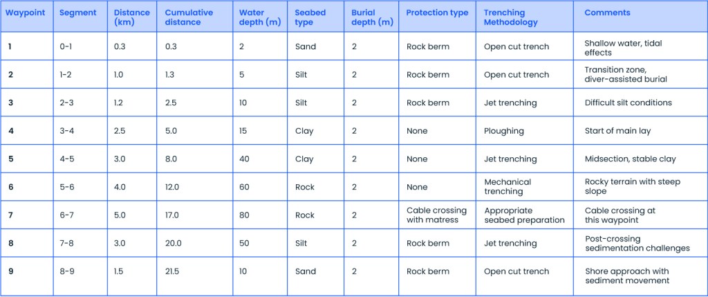
The influence of depth on submarine cable installation methods is critical in determining the appropriate approach for each segment of the route. In shallow waters (0–10 m), challenges such as limited vessel manoeuvrability and increased sediment displacement due to tidal effects require tailored methodologies. Open cut trenching, combined with diver-assisted operations, is typically used for precise cable placement and burial. For instance, Waypoints 1–3 in the RPL involve sandy and silty seabeds, where rock berms are added to provide additional protection and stability.
In intermediate depths (10–50 m), varying seabed types, including cohesive soils and loose sediments, demand flexible and efficient tools. Jet trenching and ploughing are the preferred methods for soft sediments like silt and clay, ensuring that target burial depths are achieved. At Waypoints 4–5 in the RPL, stable clay dominates, enabling efficient application of these methods while maintaining burial accuracy.
In deep waters (50–80 m), challenges such as rocky substrates, steep slopes, and reduced visibility necessitate the use of specialised tools and robust methodologies. Mechanical trenching with precision cutting tools is employed to handle rocky terrains effectively. For example, Waypoints 6–7 in the RPL require mechanical trenching, which is used in conjunction with mattress protection to safeguard cable crossings and maintain structural integrity.
Segregating the laying methods further refines the installation process based on depth and seabed conditions. In shallow zones (0–10 m), open cut trenching is the preferred method for sandy and silty seabeds, as seen at Waypoints 1–3, where rock berms stabilise the trench and protect against tidal forces. For the main lay (10–80 m), jet trenching and ploughing are utilised for cohesive soils like clay and silt in intermediate depths, transitioning to mechanical trenching in deeper waters for rocky substrates, as illustrated at Waypoints 4–7. In landing zones (0–5 m), Horizontal Directional Drilling (HDD) is employed for rocky and environmentally sensitive shorelines to minimise surface disturbance. At Waypoint 10, an HDD conduit protects the cable during its transition to the shore, ensuring environmental and structural integrity.
This structured approach, guided by the RPL, enables the selection of appropriate methodologies for each segment, optimising the installation process and ensuring project success.
The selection of vessels for submarine cable installation is critical and varies depending on water depth and operational requirements, as guided by the RPL. In shallow water operations (0–10 m), multi-purpose support vessels (MPV) are used for open cut trenching and diver-assisted burial operations. These vessels are specifically equipped to manage sediment displacement and ensure precise cable placement. For example, at Waypoints 1–3 in the RPL, sediment is stabilised using diver support and rock berm placement to mitigate tidal impacts.
For the main lay operations (10–80 m), Dynamic Positioning Cable-Laying Vessels (DP CLVs) are the preferred choice. These vessels are equipped with advanced features such as jet trenchers, cable tension control systems, and remotely operated vehicles (ROVs) for real-time monitoring and adjustment. At Waypoints 4–7 in the RPL, DP CLVs enable efficient ploughing and trenching in varying seabed conditions, ensuring the required burial depth and route alignment are maintained.
In landing zones (0–5 m), HDD rigs supported by marine vessels are utilised to execute Horizontal Directional Drilling (HDD) and cable pull-in operations. These rigs are specifically designed for smooth transitions in challenging conditions such as rocky terrains or environmentally sensitive areas. For example, at Waypoint 10 in the RPL, HDD ensures that the cable is securely installed with minimal surface disturbance while maintaining structural integrity during its transition to shore. This tailored vessel selection ensures that the methodology aligns with the specific requirements of each segment in the RPL, enhancing operational efficiency and project success.

The selection of burial tools is critical for achieving the required burial depth and protecting the submarine cable. The RPL provides essential information on seabed characteristics, enabling the selection of appropriate tools for each segment of the route.
The jet trencher is suitable for sandy and silty seabed’s, offering efficient burial in soft sediments. It uses high-pressure water jets to fluidise the seabed, allowing the cable to settle into the trench. For instance, at Waypoints 3, 5, and 8 in the RPL, loose silt conditions necessitate controlled trenching, making the jet trencher an ideal choice for these segments.
The mechanical trencher is designed for rocky substrates and hard soils, providing precise trench excavation. It utilises cutting tools to handle challenging terrains effectively. This tool is particularly critical at Waypoint 6 in the RPL, where rocky terrains demand robust equipment to achieve the desired burial depth while ensuring cable integrity.
The cable plough is best suited for cohesive soils like clay, enabling consistent burial depths over long stretches. The plough displaces the soil to create a trench, simultaneously laying and burying the cable. At Waypoint 4 in the RPL, where stable clay predominates, the cable plough ensures efficient and uniform burial, minimising the need for additional intervention.

By aligning burial tool selection with the seabed conditions detailed in the RPL, project teams can ensure efficient and reliable cable installation while addressing the specific challenges of each segment.

The Route Position List (RPL) serves as a vital resource for a variety of stakeholders involved in submarine cable installation projects, streamlining processes and ensuring efficiency. For EPC contractors, the RPL provides detailed route data that enables effective planning of tools, resources, and methodologies while mitigating potential risks during installation. It also serves as a critical input for accurate project cost estimation by detailing segment-specific requirements such as burial depths, seabed conditions, and protection measures. By referencing the RPL, contractors can align their execution strategies with the unique challenges of each segment, thereby reducing delays, minimising unexpected challenges, and optimising overall project costs.
For owner’s engineers (OEs), the RPL is an essential tool to validate the design and installation methods against project specifications and regulatory requirements. It ensures that all planned activities align with the long-term reliability of the cable system, offering a framework for technical assessments and quality assurance.
Project managers benefit from the RPL by using it as a reference for coordinating resources, budgets, and timelines. The comprehensive nature of the RPL allows managers to monitor progress effectively, ensuring that each phase of the project stays on track and within the defined scope.
For regulatory authorities, the RPL simplifies the process of assessing compliance with environmental and maritime regulations. By providing a detailed account of the cable route, seabed conditions, and planned methodologies, the RPL supports authorities in evaluating and approving installation activities, ensuring adherence to all legal and environmental standards.
The RPL’s detailed and structured data fosters collaboration among all stakeholders, enhancing decision-making and ensuring the successful execution of submarine cable projects.
The Route Position List (RPL) is a critical tool for ensuring the efficient planning and execution of submarine cable installations. By consolidating key data such as water depths, seabed types, and burial requirements, it provides a clear and structured guide for addressing project challenges and ensuring compliance with environmental regulations. An accurate and well-prepared RPL simplifies decision-making, aligns methodologies with site-specific conditions, and enhances the reliability of submarine cable systems. It remains an indispensable resource for the successful execution of cable installation projects.