Dhaka Outer Ring Road Feasibility Study and Preliminary Design

From the early pioneers on the Snowy Mountains Hydroelectric Scheme, to our leaders and innovators of today, our people make us who we are.
Through our network of global specialists and by collaborating with local partners, we connect you with the best teams and capabilities to deliver highly innovative and sustainable solutions.
As an organisation we are continually evaluating ways we can better provide a safe, flexible, inclusive and respectful workplace for our people and clients.
People are at the heart of our organisation, we strive to create a flexible, diverse and inclusive environment that enables our people to thrive to their fullest potential.
Explore career opportunities
SMEC brings extensive experience in delivering complex feasibility studies and preliminary designs for major transport and urban infrastructure projects across Asia and the Pacific. Leveraging expertise in transport planning, traffic modelling, geotechnical engineering, and multidisciplinary assessment, SMEC supports governments and agencies in developing solutions that are technically robust, economically viable, and socially responsible.
For the Dhaka Outer Ring Road, SMEC applied this expertise to assess the corridor’s feasibility, optimise alignment, and develop a refined concept design that balances strategic objectives with on-the-ground realities in one of the world’s fastest-growing megacities. Critical factors included:
Through extensive field investigations and multidisciplinary analysis, our team developed a suite of foundational studies that shaped the final concept design. Every element of the proposed corridor—from alignment selection to traffic capacity, sustainability considerations, and long-term urban resilience—was grounded in evidence, informed by advanced analytics.
The final concept design recommendations included:
SMEC also explored funding and delivery options, including Public-Private Partnership (PPP) frameworks, with a focus on the Build-Operate-Transfer (BOT) model, to support subsequent project phases and ensure the Outer Ring Road’s long-term sustainability. Together, these insights and technical assessments underpin a concept design that responds to Dhaka’s transport challenges today while future-proofing the city’s mobility network for decades to come.
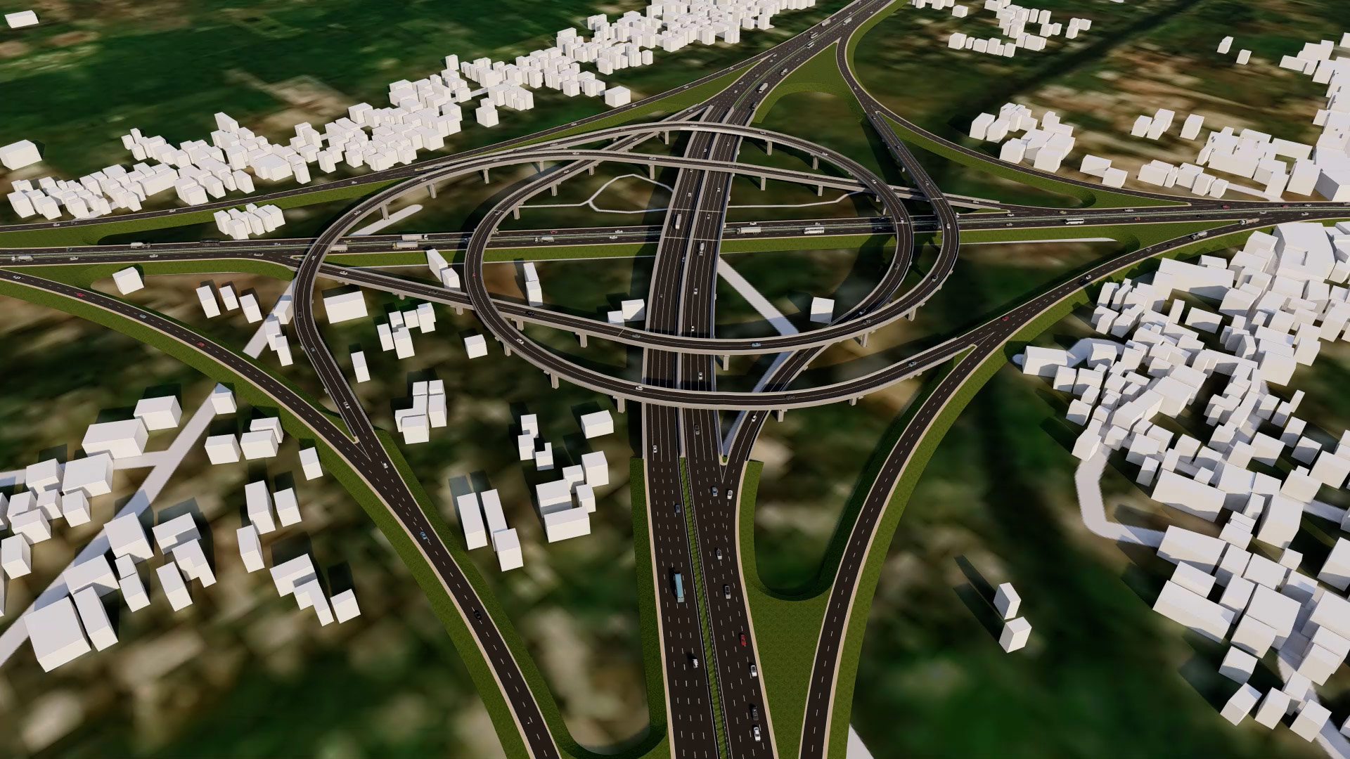
The Dhaka Outer Ring Road’s concept design was informed by rigorous technical analysis, leveraging advanced Geographic Information Systems (GIS) modelling, drone imagery, and multidisciplinary expertise. SMEC’s team evaluated multiple alignment options using a comprehensive Multi-Criteria Analysis, balancing engineering, social considerations, environmental sensitivity, and cost factors to identify the corridor best suited for Dhaka’s evolving urban needs.
A key element of the evaluation involved the use of high-resolution drone-based topographic and reconnaissance surveys, providing spatial data with up to 20 cm accuracy. This enabled precise mapping of terrain features, assessment of land availability, and identification of potential physical and environmental constraints. This technology allowed the integration of insights to refine the ring road’s alignment, avoiding densely populated or environmentally sensitive zones, minimising resettlement and ecological impacts. The use of drones also improved survey efficiency and safety, compared to traditional methods.
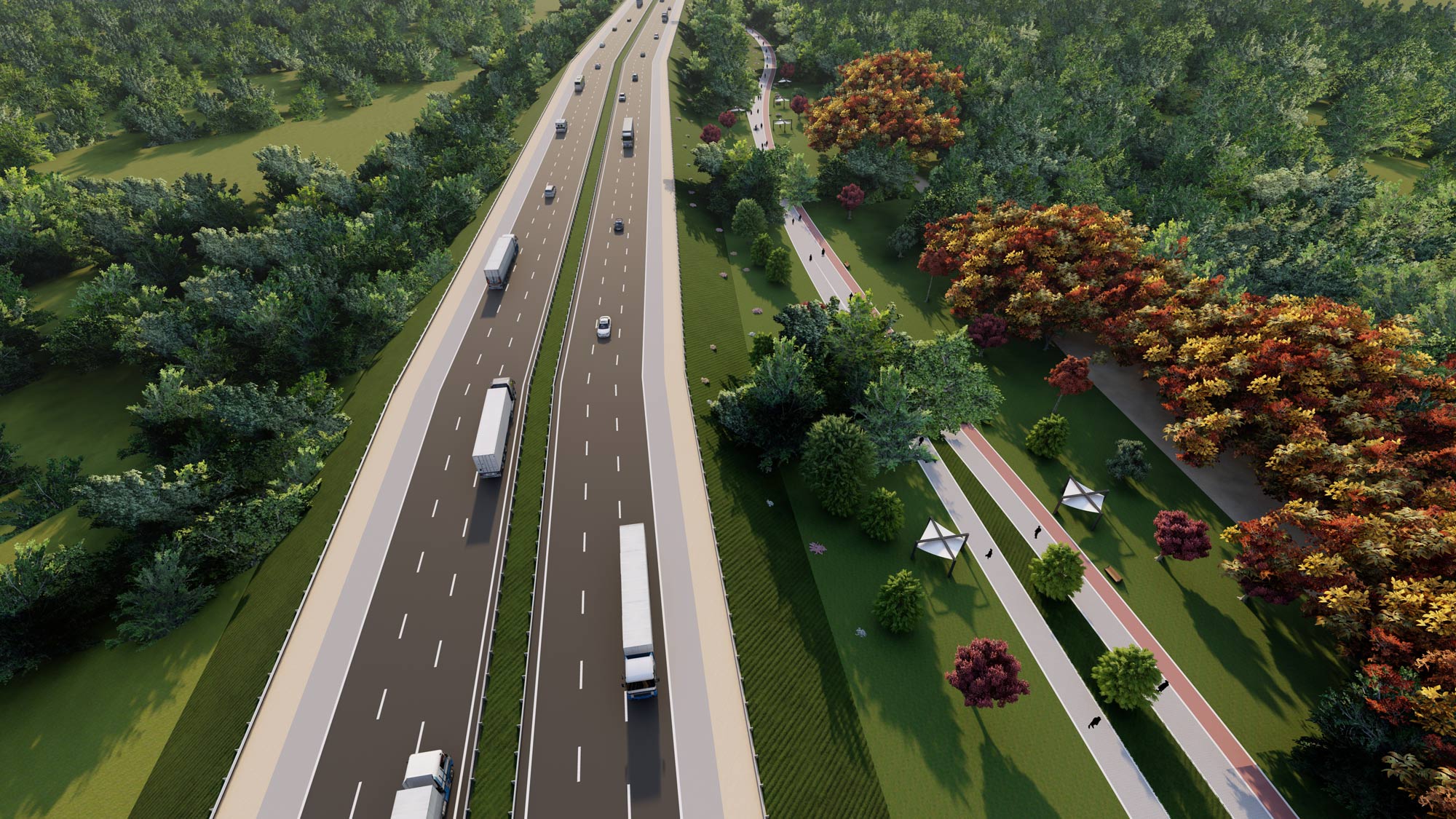
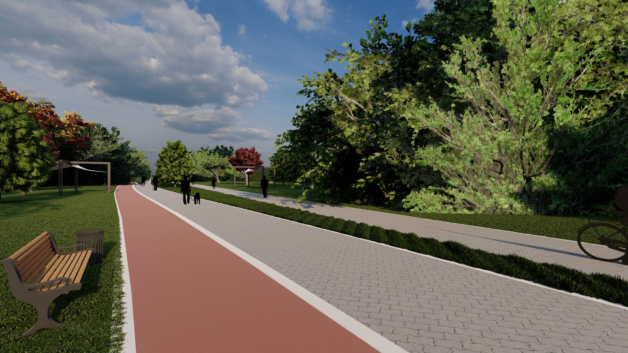
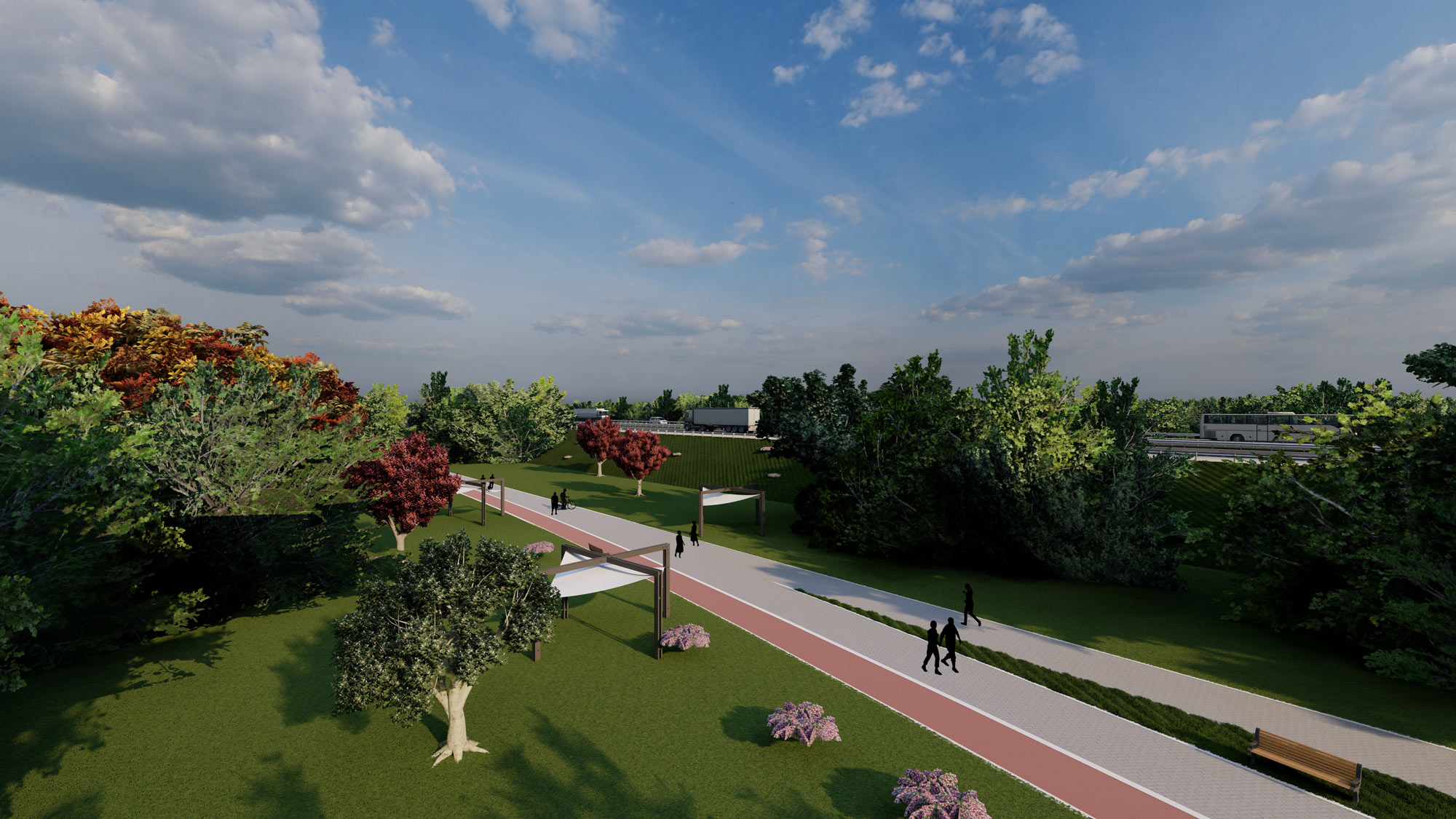
Sustainability was embedded throughout the design process, with green infrastructure forming a core principle. The proposed corridor incorporates a green belt, parks, and ecological buffers designed to enhance environmental resilience, support community wellbeing and improve the public realm. These features not only support biodiversity and ecological health but also create lasting social and recreational value reinforcing Outer Ring Road’s role as a project that integrates transport efficiency with positive urban outcomes.
To ensure Dhaka Outer Ring Road delivers long-term effectiveness and resilience, SMEC conducted in-depth population projection and urban growth modelling, analysing historical settlement trends alongside current urbanisation patterns. These forecasts informed alignment selection, ensuring the corridor remains strategically positioned beyond future urban sprawl while preserving its intended bypass function for the metropolitan area.
Our team leveraged advanced GIS analytics and satellite imagery to model future population distribution and urban expansion patterns over the next 10-20 years, enabling the design to remain functional and outside projected high-density urban growth zones.
A refined resettlement impact assessment was developed using telemetric drone videography, integrated with chainage-referenced mapping. By aligning the drone imagery directly with the proposed corridor chainage, the team was able to accurately identify affected structures, estimate relocation requirements, and optimise the alignment to minimise social impacts. This method enhanced precision, reduced the need for intrusive fieldwork in sensitive areas, and improved stakeholder confidence in the project’s findings.
SMEC utilised GiMS, its in-house web-based GIS platform, to manage, integrate, and visualise multi-source datasets throughout the study. This tool enabled seamless coordination between survey data, alignment options, environmental features, and demographic layers, supporting robust, evidence-based decision-making and transparent data governance.
Using detailed traffic studies and demand forecasting models, the team determined lane requirements and planned for future capacity. Analysis showed that the recommended Outer Ring Road alignment could divert substantial traffic away from central Dhaka including:
Beyond reducing congestion in inner-city Dhaka, the recommended design improves connectivity among major satellite towns and supports economic decentralisation. Modelling of the recommended alignment demonstrated significant reductions in inter-city travel times.
For example, the current 3–3.5-hour journey between Gazipur and Narayanganj could be reduced to less than one hour.
The study also recommended measures to enhance the economic and strategic viability of the road, such as congestion charges on inner-city roads, to further encourage traffic diversion and improve air quality in central Dhaka, maximising both transport efficiency and environmental benefits.
At SMEC, sustainable design is central to infrastructure planning. For Dhaka Outer Ring Road, our team incorporated a suite of sustainability features to deliver lasting environmental, social, and operational benefits for Dhaka and surrounding areas. The city’s chronic congestion, prolonged vehicle idling, and high humidity have increasingly contributed to poor air quality throughout the region. By addressing these contributing factors, SMEC’s Feasibility Study and Preliminary Design demonstrate how a strategically planned bypass can improve urban mobility, health, and quality of life for communities.
SMEC’s feasibility study identified that a significant proportion of vehicles currently passing through Dhaka are destined for locations outside the city and do not require central access. By providing a high-speed, access-controlled alternative, Outer Ring Road allows these vehicles to bypass the city entirely.
Traffic modelling indicated that inner-city traffic volumes could be reduced by up to 36%, and travel time between major satellite towns could be reduced by a third.
These improvements translate into major socio-economic benefits, including increased productivity, reduced travel fatigue, and better access to jobs, education, and services. Reduced stop-and-go driving, idling and engine loading will lower emissions of carbon monoxide, nitrogen oxides, and particulate matter delivering tangible improvements in regional air quality, and contributing to long-term environmental resilience.
A green buffer zone alongside both sides of the expressway enhance climate resilience and urban biodiversity by absorbing airborne pollutants and dust, offsetting a portion of vehicle carbon emissions and serving as a natural noise barrier. The green belt also improves the visual and ecological quality of the corridor, while providing safe recreational spaces for local communities.
Placing sustainability at the forefront, SMEC explored innovative alternatives to conventional traffic management, such as integrating solar-powered road studs in place of traditional highway lighting. These advanced studs not only provide effective nighttime guidance for motorists, but also significantly reduce energy consumption, limit light pollution, and lessen glare and disruptions for nearby communities and natural habitats. This approach further champions the use of renewable energy and reinforces SMEC’s commitment to sustainable infrastructure solutions.
As lead consultant during the feasibility phase, SMEC is proud to have laid the foundation for one of the region’s most impactful transport initiatives. The Dhaka Outer Ring Road project embodies a sustainable, inclusive and forward-thinking approach, resulting in a design that addresses both present-day challenges and future needs. Through innovative engineering and collaborative vision, the feasibility study and concept design mark a pivotal step towards a cleaner, less congested, and more liveable Dhaka. This transformative project not only addresses today’s transport and urban challenges but also establishes a strong foundation for future generations. By prioritising lasting, positive change, SMEC reaffirms its commitment to enhancing communities worldwide and creating lasting, positive change for communities across the globe.