Expertise

From the early pioneers on the Snowy Mountains Hydroelectric Scheme, to our leaders and innovators of today, our people make us who we are.
Through our network of global specialists and by collaborating with local partners, we connect you with the best teams and capabilities to deliver highly innovative and sustainable solutions.
As an organisation we are continually evaluating ways we can better provide a safe, flexible, inclusive and respectful workplace for our people and clients.
People are at the heart of our organisation, we strive to create a flexible, diverse and inclusive environment that enables our people to thrive to their fullest potential.
Explore career opportunities
Advances in geospatial analytics, predictive modelling, automation, and real-time monitoring are helping engineers simplify complexity, optimise decision-making, and enhance sustainability at every stage of the asset lifecycle. The ability to integrate these technologies effectively is now a key differentiator for governments, asset owners, and developers seeking to future-proof critical infrastructure.

Today’s planning and feasibility studies are critical in defining viability, cost, environmental performance, and even operations. Predictive AI modelling and GIS-enabled geospatial analysis is transforming how engineers utilise data to assess risks and inform design parameters. Whether forecasting flood risks, estimating earthworks, or optimising renewable energy generation, AI and geospatial intelligence systems are allowing engineers to design with greater efficiency, and environmental awareness.
Traditional feasibility studies rely on deterministic models, which use historical data to estimate future conditions. While effective in stable environments, these models often struggle to account for climate variability or the impact of urban expansion on existing drainage systems or other infrastructure. AI and machine learning address these challenges by identifying patterns in large datasets and enabling scenario-based forecasting.
In Australia, SMEC applied digital automation to assess and refine drainage system performance for the Collina Drainage Masterplan review in Griffith, NSW. Instead of relying on manual calculations, automated hydrological modelling was used to predict peak water flow during heavy rainfall, ensuring that detention basins were designed with the right capacity to prevent flooding. The system also analysed drainage networks to identify inefficiencies, such as areas prone to pooling or underperforming infrastructure.
By leveraging data-driven insights, engineers optimised the stormwater system to enhance flood resilience, reduce maintenance costs, and ensure long-term compliance with council regulations. As AI-driven predictive modelling continues to evolve, its role in resource optimisation and climate resilience, will become even more integral to feasibility studies and ongoing asset management.

Geospatial intelligence has become an essential tool in the early planning stages of infrastructure and energy projects. Aerial LiDAR, GIS, and 3D modelling integrate multiple data layers, streamlining flood risk mapping, ecological assessments, and infrastructure constraints.
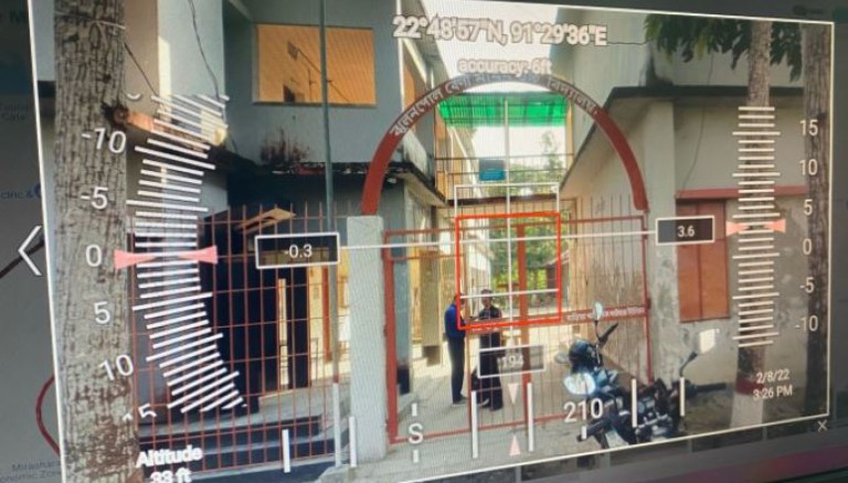
Photogrammetry has evolved as a powerful digital mapping tool for short term decision making and long-term management. By creating precise digital records of assets such as dams and tunnels, engineers can capture an accurate snapshot of their condition at any given moment. As infrastructure ages, these digital archives support proactive maintenance planning, risk assessments, and operational decision-making.
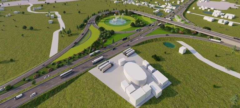
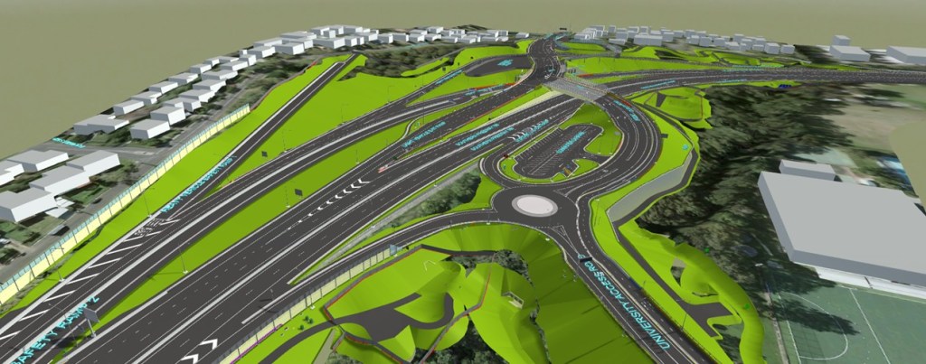
At Mount Ousley Interchange, SMEC applied 3D terrain modelling and geospatial analysis to improve earthworks efficiency, optimise material use, and reduce environmental impact. By isolating Industry Foundation Classes (IFC) for key quantities, the team ensured precise cost estimation and better alignment with site constraints. During the tender for the D&B contract, analysis undertaken by SMEC enabled the contractor to reduce earthworks volumes by 90%, from 370,000m³ to just 40,000m³.

The use of digital technology is transforming infrastructure design, making projects more efficient, sustainable, and easier to coordinate at an unprecedented scale. Engineers now have access to tools that track carbon emissions in real time, automate material selection to reduce waste, and apply AI-driven modelling to improve design accuracy. These innovations help streamline engineering performance, enabling seamless collaboration across highly complex, multi-disciplinary projects. As industries work towards net zero targets and smarter ways of building, digital solutions will be key to delivering infrastructure that is both future-ready and environmentally responsible.
Given the scale and complexity of today’s mega infrastructure, manual design coordination is too impractical. By reducing repetitive tasks, automation is helping engineers streamline parametric design and enhance coordination across disciplines.
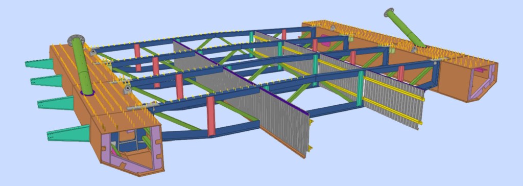
At SJ the aviation team has developed automation-first workflows to enhance design coordination across multiple disciplines, reducing errors and rework on one of its iconic projects. The integration of advanced digital modelling tools has been instrumental in achieving precision coordination between complex structural components, geotechnical constraints, and mechanical systems. By establishing structured data processing and synchronised file management, the design team has collaborated seamlessly in a real-time digital environment, improving efficiency at every stage.
In Africa, our tunnelling experts have utilised specialised 3D modelling software to develop structural designs while simultaneously mapping tunnel alignment and geological conditions. Automated data exchange ensured seamless integration between structural and geotechnical models, preserving accuracy in tunnel geometry, and preventing clashes between the new tunnel lining and the existing structure.
On large-scale solar projects, SJ and SMEC leverage digital modelling to improve design accuracy and streamline stakeholder coordination. Simulation tools support detailed analysis for clash detection and energy forecasting, while intuitive visualisations make it easier to communicate complex information. This clarity encourages collaborative decision-making and enables rapid design adjustments based on stakeholder feedback.
Digital tools are supporting sustainability objectives such as reducing embodied carbon, minimising waste, and designing infrastructure for longevity. Today, project teams can assess material choices and compare environmental impacts to integrate sustainability into the design process. The use of Material Passports, which track material origin, lifecycle performance, and recyclability, is emerging as a best practice in reducing construction waste and improving long-term asset sustainability.
For example, in Mount Ousley Interchange, SMEC used automated digital quantity extraction to track cost and embodied carbon in real time, helping decision-makers understand the carbon impact of different material choices. The project explored direct API integration with the EC3 Embodied Carbon Calculator, a globally recognised tool that enables engineers to instantly quantify emissions associated with concrete, steel, and other construction materials.
Similarly, in South Africa, SMEC recently applied BioWin Process Simulation to a Centralised Wastewater Treatment Works project to optimise treatment efficiency and reduce energy consumption. The model aimed to ensure reduced chemical dosing, energy usage, and treatment performance, ensuring that the plant was designed to minimise operational carbon emissions over its lifecycle.
By embedding carbon assessment, lifecycle tracking, and digital sustainability strategies into design workflows, SMEC is ensuring that environmental impact is measurable, optimised, and integrated from the outset.
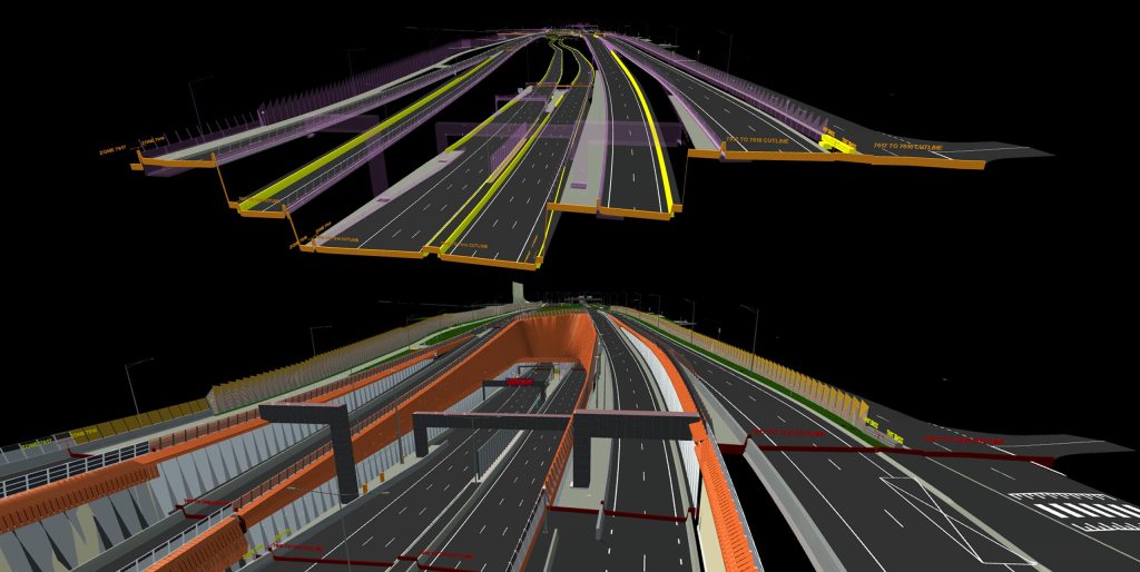
One of the most complex stages in any project is translating design into construction. Digital tools are ensuring that projects transition with greater assurance and more efficient execution with fewer errors. By integrating Building Information Modelling with advanced computational modelling and engineering simulations, engineers can validate designs in real-world conditions before breaking ground.
BIM is the foundation of modern infrastructure design, enabling real-time coordination across different services and engineering disciplines e.g. civil, structural, geotechnical, MEP. On large-scale projects, BIM ensures every design component fits together before construction begins, reducing clashes and delays.
Computational modelling complements BIM by predicting how infrastructure will perform under real-world conditions. By integrating these tools within a 3D federated model, engineers can refine designs to improve resilience and efficiency before construction begins. Finite Element Modelling (FEM), Computational Fluid Dynamics (CFD), and geotechnical simulations allow engineers to assess structural performance, ventilation efficiency, flood risks, and ground movement—ensuring that critical infrastructure is optimised for safety and long-term durability.
At Chennai Metro in India, architectural and MEP models have been synchronised with transport alignments and grading systems, ensuring accurate coordination of station platforms, drainage networks, and track geometry.
Underground metro projects often face tight space constraints, complex geotechnical conditions, and high land acquisition costs. In Chennai, SMEC engineers addressed these challenges by designing stacked metro stations, reducing the station footprint to just 11 metres wide, a 40% reduction compared to conventional underground stations.
BIM-enabled coordination allowed MEP and ventilation systems to be integrated into a single room, lowering equipment costs by 35%. Finite Element Modelling (FEM) and geotechnical digital analysis ensured that tunnels passed safely beneath existing Phase 1 metro infrastructure, preventing ground settlement and structural risks.

Operations and maintenance (O&M) represent the longest and most critical phase of an asset’s lifecycle. With increasing demands for resilience, efficiency, and sustainability, digital technologies such as Internet of Things (IoT), Supervisory Control and Data Acquisition (SCADA) and digital twins have revolutionised how infrastructure is monitored and managed.
The integration of smart sensors and digital modelling is redefining asset management, enabling assets to be monitored and maintained in real time. While IoT sensors provide real-time operational insights, digital twins take asset management further by creating a dynamic, data-driven replica of infrastructure systems. These tools allow operators to simulate performance scenarios, test maintenance strategies over the full asset lifecycle.
Traditional maintenance relies on periodic inspections and reactive repairs, often leading to unexpected downtime and costly emergency fixes. IoT-enabled infrastructure shifts this to real-time monitoring and predictive maintenance, ensuring proactive asset management.
Equipped with a structural health monitoring system, Msikaba Bridge will use IoT sensors to track real-time data on strain, wind, displacement, and temperature. The system’s predictive capabilities provide early warnings for hazards like high winds or unexpected structural shifts, reducing risks and enhancing user safety.
In solar farms across ANZ, SMEC has deployed IoT-enabled SCADA systems to automate performance tracking. The ability to detect efficiency losses or grid fluctuations in real time has optimised asset operations while reducing maintenance costs.
Digital transformation is fundamentally changing the infrastructure sector, driving significant advancements in how projects are planned, designed, built, and managed. The integration of advanced digital tools and automation is fostering innovation and efficiency across the entire project lifecycle.
From initial feasibility studies to long-term asset management, technologies like AI, geospatial intelligence, BIM, IoT, and digital twins are helping developers, governments and asset owners, future-proof critical infrastructure. By embracing data-driven approaches, the industry is optimising project outcomes and fostering greater sustainability, resilience, and long-term value for infrastructure assets worldwide.
Advancements in digital and Internet of Things (IoT) technology are reshaping how we design, operate, and maintain mega structures.
Leveraging the latest advances in digital engineering, SMEC South Africa continues to refine its virtual design capabilities to optimise the construction, maintenance, and asset management of transportation routes.
Complex highway projects require meticulous planning and consideration. At SMEC, Geographic Information Systems (GIS) technology has emerged as a powerful tool, adding value for our clients and partners across all stages of the project lifecycle as well as ongoing asset management.
Complex highway projects require meticulous planning and consideration. At SMEC, Geographic Information Systems (GIS) technology has emerged as a powerful tool, adding value for our clients and partners across all stages of the project lifecycle as well as ongoing asset management.